Context
Lancaster’s most prevalent land uses are residential (27.6%) and commercial (25.5%). These two uses are located throughout the city, with a central commercial core in the downtown and along major streets. Community services (10.0%), which includes libraries, schools, hospitals, and emergency services, are also located throughout the city. Industrial uses (11.5%) are generally in the annex areas beyond the original city grid. Roughly nine percent of Lancaster’s land is vacant. (Figure 4-1)
There is a significant difference in character between the historic core of Lancaster City and the annexed areas on the northwest, northeast, and southeast. The heart of the city is comprised of small parcels that are densely developed, with a fine-grained, urban character. The areas annexed during the mid 20th Century are more suburban, with larger parcels and more auto-oriented building forms. The City has 16 zoning districts that respond to prevailing character and form. In older parts of the city, zoning recognizes the mixed use character of neighborhoods. It permits greater densities and more diverse land uses. Compatibility between uses is managed through specific zoning standards, approval conditions for new development, and various codes and regulations.
Since the advent of modern city planning, most land use plans have used siloed land use categories. These categories presume that different land uses (such as housing and retail) must be separated and designed principally for convenient access by car. Such categories overlook the importance of mixed-use neighborhoods and the historic form of older American cities. In the historic core of Lancaster City, neighborhoods are not entirely residential or commercial. They include different uses, building forms, and activities that intersect and co-exist in organic ways.
Lancaster City’s vision for its future land use presents a more holistic vision and strategy for community development. The Future Land Use Map incorporates land use categories that embrace the city’s unique mix of building types and land uses. These categories reinforce Lancaster as a vibrant, distinctive, and walkable community. The policies in this chapter aim to enhance those attributes and even extend them into areas of the City that may see redevelopment in the future.
Special consideration has been given to the relationship between the built environment, the natural environment, and the transportation network. Future land uses reflect and support the transportation system and vice versa. Built areas transition to natural areas in ways that connect residents to nature and promote resilience and environmental health. The result is a vision for future land use that reflects the policies throughout this Comprehensive Plan and serves as a clear decision-making guide for growth and reinvestment.
Components of Future Land Use
Figure 4-2 is the Future Land Use Map (FLUM) for Lancaster City. The Map shows the pattern of land uses envisioned within the city limits by the horizon year of this Plan. In most cases, the designation of a given site reflects its current use, but in some cases new uses are shown, indicating future land use change. Future land use and development decisions should not be inconsistent with the designations on this map, nor the definitions of each category provided in this chapter.
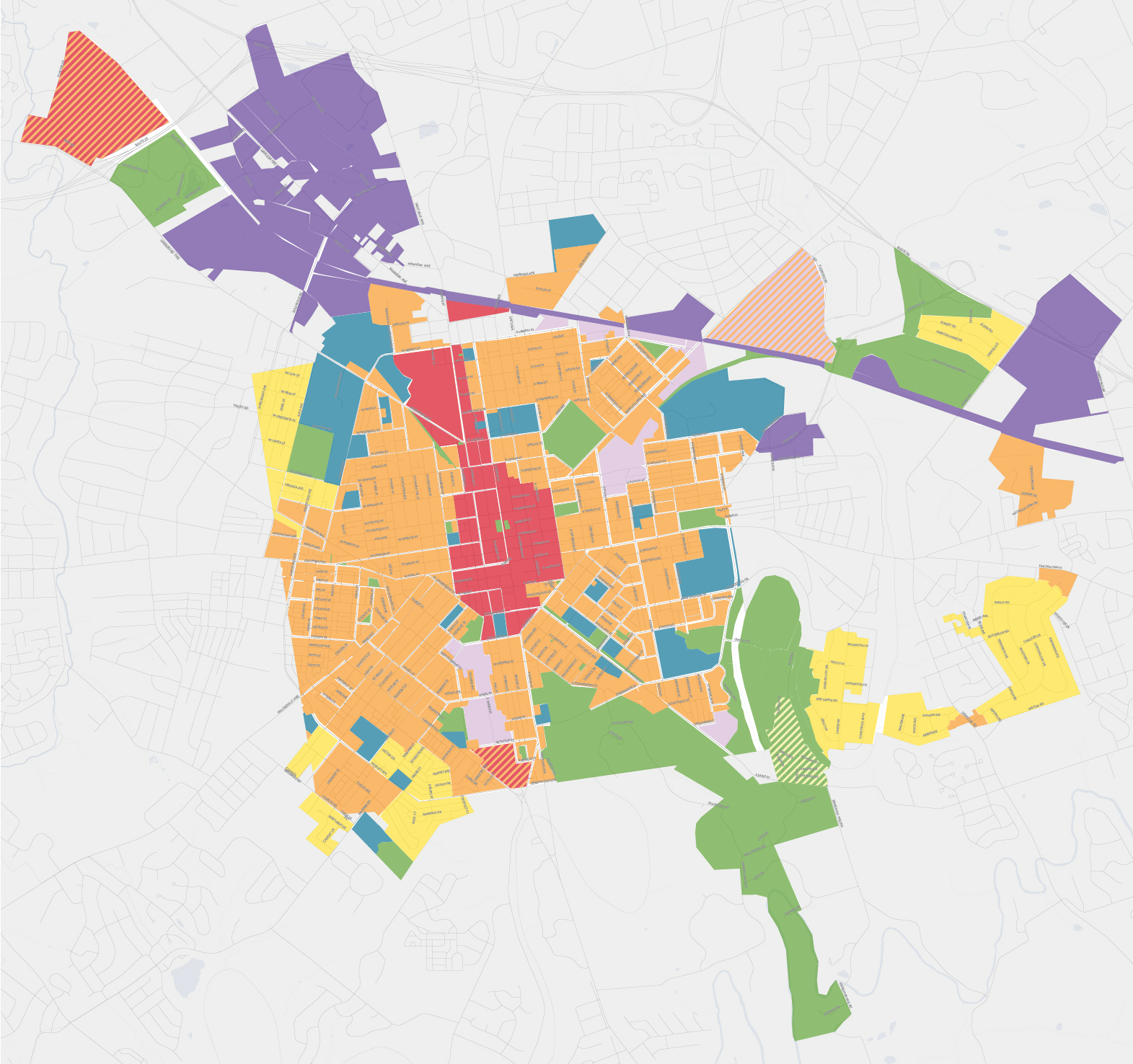
Figure 4-2: Future Land Use Map (FLUM)
The FLUM is not the same as the zoning map. Zoning maps are parcel-based and correspond to districts with prescriptive regulations for what may be built, including standards for height, yards, parking, and so on. The FLUM is more generalized and is used to make long-term decisions about infrastructure, investment, and development.
A total of seven categories appear on the FLUM, plus an eighth category used for dual land uses (areas where more than one land use may be appropriate). Descriptions of each category appear below, including distinguishing characteristics and common elements. The characteristics may vary across each category, reflecting historic development patterns, natural features, and other factors.
The following components are included in each description below:
- Definition: a brief statement conveying the general intent of each land use category. The colors in the text correspond to the FLUM legend.
- Development Styles: a description of the existing and future physical character of the area, especially regarding land uses and building types.
- Ground Floor: where appropriate, guidance is provided on how the ground floor of a building should be used.
- Mobility: a description of how people are expected to travel through the area and what infrastructure may be present to facilitate that.
- Intensity: a description of lot and building characteristics, including height, setbacks, and lot size.
- Primary Uses: a description of the predominant land uses found in the area.
- Secondary Uses: a description of the supporting uses that are sometimes found in the area. Certain secondary uses may be more appropriate along Main Street Corridors or within Commercial Hubs (see Economic Development Policy Map).
DESCRIPTIONS of Future Land Use CATEGORIEs
Residential (RES)
Definition: Moderate-density neighborhoods with medium-sized lots and incidental small-scale commercial amenities.
Development Style: Housing set back from the street. Future development includes single-family, two-family, low-rise multi-family, accessory dwelling units, and live-work units, which are built to a scale and layout consistent with existing buildings. Most parcels have front, back, and side yards.
Ground Floor: Not applicable
Mobility: Bicycle and pedestrian facilities are accommodated. Frequent transit is found near these areas but may not exist within them. On-street parking is common, although some houses have driveways and garages accessed from the front, side, or alleyway.
Intensity: Buildings are generally one to three stories. New development has nine dwelling units per net acre or greater.
Primary Uses: Single-family houses, accessory dwelling units, live work units, and open space
Secondary Uses: Cultural and institutional uses, which generally occur along higher-volume streets.
NEIGHBORHOOD MIXED USE (NMU)
Definition: Medium-density residential neighborhoods with occasional neighborhood-scale commercial amenities.
Development Style: Housing situated on relatively small lots with sidewalk-adjacent front porches, stoops, small front yards, or no front setbacks. Service alleys are typical, but side yards are less common. Future development includes dense single-family, two- to four-family, multifamily, accessory dwelling units, live-work units, and mixed use buildings, which are built to a scale and layout consistent with existing buildings.
Ground Floor: Building façades engage streets with windows, doors, stoops, porches, and other elements that are consistent with surrounding buildings. Storefronts for smaller, neighborhood-scale commercial retail/services may be common at or near intersections and along Main Street Commercial Corridors.
Mobility: Bicycle, pedestrian and transit facilities are accommodated, and frequent transit is accessible nearby. On-street parking is prioritized. Front driveways are generally incompatible but service alleys and rear parking are provided wherever possible.
Intensity: Buildings are generally two to six stories and are commonly attached. The building size, density, and uses may vary depending on neighborhood context.
Primary Uses: Single-family houses, accessory dwelling units, two- to four-family, live work units, multi-family, and open space.
Secondary Uses: High-density residential uses, cultural, institutional, and neighborhood-scale commercial uses. These uses typically occur along Main Street Corridors (see Economic Development Policy Map) or at intersections.
URBAN CENTERS (UC)
Definition: Compact, mixed-use neighborhood that serves as an employment center, regional destination, and neighborhood with mixed-use and high-density residential buildings.
Development Style: Development patterns are urban, pedestrian- and transit-oriented, and pay special attention to the public realm. Buildings are frequently horizontally and vertically mixed, with upper floors that accommodate both commercial and/or residential uses. New development may be larger in scale but should respond thoughtfully to the surrounding historic character and context. Appropriate block lengths and through-site pedestrian routes are necessary.
Ground Floor: Active ground floor uses that engage the public right-of-way are required. Street-fronting façades use features that create transparency and interaction with the public, such as windows, doors, storefronts, and other engaging elements. Activation of the public realm (e.g., sidewalk cafes and seating) is promoted where space permits.
Mobility: Urban Centers are transit-oriented and accommodate several modes of transportation. Bicycle, pedestrian and transit facilities are provided throughout and are prioritized. The streetscape is highly amenitized for maximum pedestrian comfort and safety. Surface parking lots are prohibited as a principal use and accessory parking is located at a building’s rear, accessed from a side street and appropriately screened. Parking requirements are minimal to none. Driveways are unfavorable along primary street frontages and instead occur along alleys and side streets.
Intensity: Buildings typically range from three to 12 stories and are commonly attached. Low-scale buildings may exist adjacent to new taller buildings.
Primary Uses: Mixed-use buildings with multi-family, pedestrian-oriented commercial, institutional, government, cultural, and open space.
Secondary Uses: Institutional, government, single-family homes, two- to four-family, and live-work units.
INSTITUTIONAL (INST)
Definition: Defines relatively cohesive groups of buildings and public spaces owned by public or quasi-public institutions such as colleges, universities, schools, hospitals, religious organizations, non-profits, and supportive services.
Development Style: Institutions may have a variety of uses onsite. Buildings may vary by type and size depending on the particular use. An institutional use may occupy one large site or multiple adjacent sites that are aesthetically integrated. New development works towards a unified appearance for the institution and adaptive reuse of existing historic structures. Building and site design fosters connections to the public realm and adheres to the desired block structure and street network.
Ground Floor: Buildings adjacent to streets are designed with active ground floor uses that engage the public. Street-fronting façades use features that create transparency and interaction such as windows, doors, and storefronts.
Mobility: Bicycle, pedestrian and transit facilities are accommodated, and frequent transit is standard. Institutional uses often have internal pedestrian or street networks and promote multi-modal transportation connections. Structured parking may be suitable, but surface parking is prohibited adjacent to street frontages.
Intensity: The intensity of development may vary significantly between buildings, lots, and different types of uses. Building heights are a minimum of two stories and generally no more than six stories, although some high-rise construction may be suitable for more intensive uses.
Primary Uses: Primary uses may vary depending on the institution and may include office, research and development, government, cultural, education, recreation, and open space.
Secondary Uses: Commercial, multi-family, hospitality, and other accessory uses intended to support workers, visitors, and residents. A small portion of non-institutional uses exist within this district.
GENERAL COMMERCIAL/INDUSTRIAL (GCI)
Definition: Areas generally, but not exclusively, suited for high-intensity industrial and regional commercial uses that draw from a broad market area and are connected to Limited Access Highways and other major roads.
Development Style: Buildings vary by type and size depending on the particular use, but this category is generally characterized by low- to mid-rise structures. Although some uses may require large-scale facilities with buffering and setbacks from adjacent uses, building and site design still fosters connections with the public realm and adheres to the desired block structure and street network. Redevelopment of these areas prioritizes compact and smart growth development patterns.
Ground Floor: Where it is not desirable to situate a building and/or use near the right-of-way, adequate landscape buffers are provided.
Mobility: Although existing development patterns are auto-oriented, new development enhances the public realm and accommodates pedestrian, bicycle, and transit access. Cross-access between adjoining sites helps limit the number of driveways and improves pedestrian safety. Parking is located at a building’s rear, accessed from a side street, and appropriately screened from the public right of way.
Intensity: Buildings are generally one to six stories and are commonly detached. Lot sizes are relatively large with increased setbacks, and intensity may vary significantly. Common nuisances (e.g., traffic, noise, odors, glare) are mitigated through high quality site design. Ingress and egress are designed to limit impacts on neighborhoods and open spaces.
Primary Uses: Industrial, light and heavy commercial, and open space.
Secondary Uses: Retail, office, and institutional.
LIGHT INDUSTRY & INNOVATION (LIO)
Definition: Areas generally within an urban context that are suited for smaller scale commercial, light industry, and emerging low-impact industrial sectors such as technology; legacy uses such as heavy manufacturing also may exist.
Development Style: Buildings may vary by type and size depending on the particular use, but this land use is generally characterized by low- to mid-rise structures. Some may be historic structures that are adaptively reused. Existing designs are largely auto-oriented but are complemented by an urban streetscape. Buffering and setbacks are limited because of the surrounding urban character, and site design fosters connections with the public realm. Redevelopment of these areas prioritizes compact and smart growth development patterns.
Ground Floor: Given the variety of building types and sizes and the potential for buffering, engagement with the public realm on the ground floor may not always be feasible but is desired where possible. Public entrances should be easily accessed via the public rights of way. For buildings being reused, the design of the original structure may present limitations for ground floor use and access.
Mobility: Surrounding development patterns are primarily mixed use and accommodate pedestrian, bicycle, and transit access. Parking is located at a building’s rear or side and is accessed from a side street as much as possible, unless adaptive reuse of a historic building creates access constraints.
Intensity: Buildings are generally one to six stories and are commonly detached. Lot sizes and intensities may vary significantly; however, uses within this district are low-impact enough that they may coexist with nearby residential uses. Potential nuisances are mitigated through high quality site design. Ingress and egress is designed to limit impacts on neighborhoods and open spaces.
Primary Uses: Light industrial, technology, and medium intensity commercial uses such as small-scale warehousing and distribution.
Secondary Uses: Retail, office, institutional, and open space.
PARKS & OPEN SPACE (POS)
Definition: Includes a broad mix of passive and active parks, open space, recreational areas, and environmental conservation, which may also include designated monuments, cemeteries, trails, and supportive facilities.
Development Style: Buildings vary according to the purpose of the open space. Uses may include but are not limited to civic buildings, maintenance buildings, community or environmental centers, rest rooms, pavilions, and other structures to support typical activities. Active uses and structures are located to limit impacts to environmental features. Limited commercial uses may be compatible in some areas
Ground Floor: Not applicable
Mobility: Bicycle, pedestrian and transit facilities are accommodated, and sites are designed to maximize access for all modes and users. Public rights-of-way and internal circulation networks are well connected. Parking is limited to maximize other public amenities.
Intensity: Built facilities are generally low-rise and sensitively integrated into the site. Intensity of use may vary significantly between different types of facilities (e.g., urban plaza, environmental conservation) but directly correlate to site conditions and intended use.
Primary Uses: Parks, open space, and environmental conservation.
Secondary Uses: Government, cultural, institutional, and essential utilities.
DUAL LAND USE (DLU)
Definition: Appears on the Map as striped with two future land use categories to indicate the area is appropriate for both land uses and/or an innovative mix of the two. Further planning and analysis is required to determine the ideal mix and locations for the land uses.
The other components (i.e., development style, ground floor, mobility, intensity, primary uses, and secondary uses) are not specified here because they are dependent on the specific land uses comprising a dual land use area. In general, a dual land use area should be reflective of the components of each respective use as defined in this chapter.